
Geomorphic Reaches
Introduction
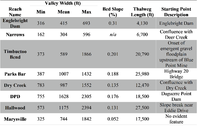
A reach is a section of river with a characteristic set of attributes controlled by the balance of sediment transport capacity, sediment supply, and topography. These governing factors are expressed through the following variables: discharge from mainstem-tributary confluences, impacts of man-made structures and activities, valley width, bed slope, and bed material type (or absence of it). Major changes in these underlying variables were used to transparently delineate the eight distinct reaches within the LYR.
Pre-Existing, Partial LYR Reach Delineation
Previously, the LYR was delineated by Beak Consultants (1989) and CDFG (1991) into four reaches: Narrows, Garcia Gravel Pit, DPD, and Simpson Lane. The only explanations provided for these reach breaks derive from their descriptions of the starting points of each: Englebright Dam, onset of emergent gravel in the floodplain upstream of Blue Point Mine, Daguerre Point Dam, and the upstream extent of the Feather River backwater effect, respectively.
Modern LYR Geomorphic Reach Delineation
Because the previous reach delineation was unclear, a new, transparent method was used to delineate eight distinct regions within the LYR segment based on the longitudinal profile and associated geomorphic variables (see table below). Tributary junctions form the upstream boundary of two reaches and dams form the boundary for two more reaches. The other reach boundaries are formed by hydro-geomorphic variables: onset of emergent floodplain gravel; transition from confined bedrock valley to wider, meandering system; and decreases in bed channel slope. Valley widths were calculated in ArcGIS using the perpendicular lines radiating from the valley centerline stations and clipped to the valley polygon. The bed slopes and lengths were calculated from the baseflow thalweg line. Reach breaks are displayed on the maps on the LYR Topography web page and in the longitudinal profile shown below.
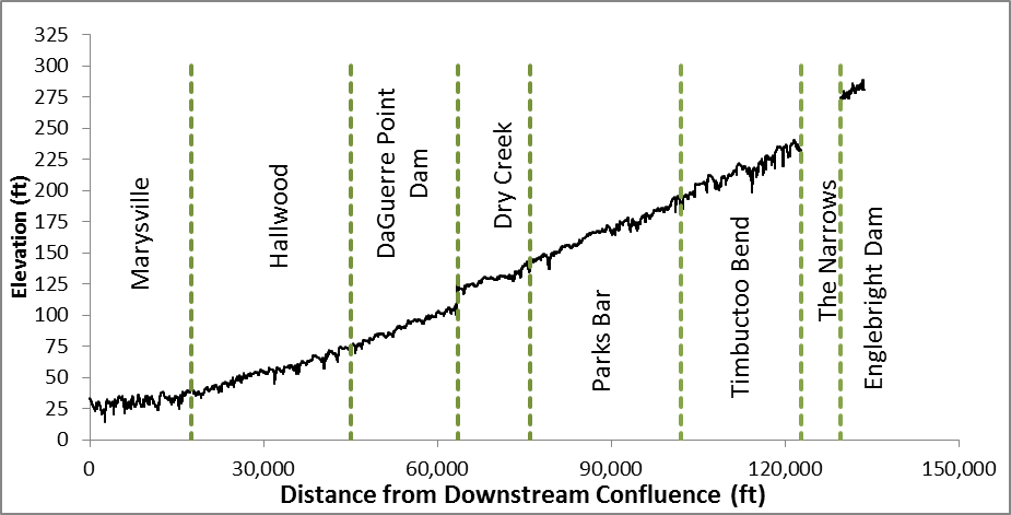
2008 LYR Longitudinal Profile
A longitudinal profile of a river is a plot of how the elevation of the deepest part of the riverbed, known as the thalweg, changes down the length of the river. Below is the 2008 LYR longitudinal profile showing the geomorphic reach breaks.
Englebright Dam Reach (EDR)
The Englebright Dam Reach is the upstream-most reach in the LYR segment, and extends from the Englebright Dam to the tributary confluence with Deer Creek. Because the dam is a sediment barrier by design, there is no river-rounded gravel/cobble substrate or finer sediments in the baseflow wetted areas in this section. As reported by Pasternack (2008), there is a residual mixture of angular gravel/cobble, probably derived from the 1997 erosion of a road or from the blasting done at the time Englebright Dam was built. There is some gravel/cobble sediment predating Englebright Dam stored on and within Sinoro Bar. The reach is girded on both sides by steep, bedrock valley walls, which create the smallest increase between baseflow width and valley width of all the reaches. The Englebright Dam reach exhibits the greatest bed channel slope and is the shortest reach.
Narrows Reach (NR)
The Narrows Reach extends from Deer Creek to the onset of emergent gravel within the floodplain near Sinoro Bar and Blue Point Mine. Similar to the Englebright Dam reach, this reach is also characterized by steep bedrock valley walls and a lack of surficial river-rounded sediments. A few cobble bars that predate Englebright Dam have persisted in the wider, upper section of the Narrows, and their subsurface composition is unknown. However, the Narrows reach becomes even more confined, which creates some Class III rapids that make topographic and bathymetric surveys very challening due to safety and accessibility issues. There is also almost no GPS signal in the Narrows, because the canyon walls block satellite connectivity. Therefore, the wetted area width, slope, and thalweg location have not been accurately determined as of yet. New data collected in 2014 make more of this possible, but have not been used for this purpose yet due to a lack of need to do so.
Timbuctoo Bend Reach (TBR)
The Timbuctoo Bend Reach extends from the emergent gravel bar at Blue Point Mine to the Highway 20 Bridge. Within the reach, the river corridor is confined by bedrock valley walls, but there is a floodplain and the channel is wider than in the upstream reaches. There exist some space for meandering within the corridor in this reach. Bedrock outcrops intersect the baseflow channel, creating hydraulic controls. At the downstream end, the valley begins to widen and transition into an alluvial, meandering system. The highway 20 bridge was located where it was, because there is a natural valley constriction there. There is a backwater effect during floods induced by this constriction, which causes gravel to deposit in the backwater zone, yielding medial bars and a braided channel planform. The reach ends at this natural constriction.
Parks Bar Reach (PBR)
The Parks Bar Reach begins at the valley widening after Timbuctoo Bend and extends to the tributary confluence with Dry Creek. Within this reach, the average valley width almost doubles from the Timbuctoo Bend reach. The extra width enables wider bankfull sedimentary bars, floodplains, islands, and terraces. The channel slope is similar, but decreasing. The upper half of the reach exhibits high bed relief as in Timbuctoo Bend, whereas the lower half has subtle bed relief.
Dry Creek Reach (DCR)
The Dry Creek Reach extends from the tributary confluence with Dry Creek to the Daguerre Point Dam. The high average valley width and presence of wide bars, floodplains, island, and terraces are similar to what is present in the Parks Bar reach; however the channel slope decreases significantly. This creates a nominally braided section with multiple flowpaths and backwater channels.
Daguerre Point Dam Reach (DPDR)
The Daguerre Point Dam Reach begins at the dam and extends to another significant slope break. This reach is characterized by a single-threaded meandering channel, with multiple floodplains, flowpaths, and backwater ponds. This is the widest alluvial reach in the segment by ~ 50%. A notable planform feature of this reach is the presence of a long parallel floodway to the north of the perennial channel, termed “Daguerre Alley” or "Hallwood Side Channel", among other names. There is a floodplain channel (i.e. flood runner) in Daguerre Alley with some permanently inundated deeper scour holes as well as a large backwater at the downstream end. This parallel floodway is separated from the main channel by a training berm that is open at both ends. The exact discharge at which this activates is unknown as of yet, but is between 10,000 to 15,000 cfs. Daguerre Alley is major focus of river restoration activity. Sometime between February 4-15, 2017, the medial training berm between Daguerre Alley and the mainstem LYR was broken through by a flood and there is now a connection between them.
Hallwood Reach (HR)
The Hallwood Reach begins near Eddie Drive where the channel decreases in bed slope and extends to another significant slope break. This reach was historically braided and anastomosing, but is now confined by levees. It is also the longest reach. The lower part of this reach that is present as a single-threaded meandering channel is presently undergoing a transformation to a braided planform toward a long-term endpoint of an anabranching planform. As a result, there is significant widening going on during floods, including erosion of adjacent agricultural land.
Marysville Reach (MR)
The most downstream reach is the Marysville Reach, which is separated from the Hallwood Reach by a slope break and encompasses the backwater zone of the Feather River. This reach was also historically wide, braided, and anastomosing, is now leveed and highly channelized. Because the levees go to the channel bank along most of its length, there is little area of floodplain landforms. The bed slope and water surface slope are very low, and the reach is therefore characterized by large areas of slow, deep waters.
Bibliography
- Wyrick, J. R. and Pasternack, G. B. 2012. Landforms of the Lower Yuba River. Prepared for the Yuba Accord River Management Team. University of California at Davis, Davis, CA, 91pp.