Topography
Introduction
Topography is the pattern of ground elevation of a landscape. It is almost impossible to know anything about the physical setting of a landscape and its role in societal or ecological problems without having a high quality topographic map. Historically, governments have provided their societies with basic topographic maps, leaving it up to local interest to make detailed maps for localized needs. Today, the National Elevation Dataset provides a square grid of the entire U.S. in ~ 10-m (33-ft) resolution. In limited areas they provide a grid in ~ 3-m (9.8-ft) resolution. For the highest resolution data in a local area, try your county surveyor's office. In California, most counties have collected topographic data at 3-ft resolution or better.
Unfortunately, the data used to make topographic maps does not capture the elevation underwater, also known as bathymetry. It takes a different methods to map riverbeds, lakebeds, and coastal waters. Of those three, there is a strong national interest in maintaining high-quality coastal navigation maps and a strong local interest in mapping lakes. In contrast, rivers are the most difficult to map and often are not mapped. The smaller the river, the less likely it is to have any topographic data. There is no local, state, or federal government entity tasked with systematically mapping rivers; it is done on an ad hoc basis for specific projects. Therefore, it is rare to have a high-quality river map.
LYR Topographic Maps
Because of the history of hydraulic mine sediments filling in the LYR valley, there were early efforts to map the river around the turn of the 20th century. In modern times, the U.S. Army Corps. of Engineers led a major river mapping campaign for the Sacramento, Feather, and Yuba Rivers in 1999. From 2000-2007 there was ad hoc mapping on a project basis by the U.S. Fish and Wildlife Service as well as the University of California at Davis. Both of those efforts focused on assessments of salmonid habitat. In 2006, UC Davis systematically mapped Timbuctoo Bend. In 2008 the Yuba Accord River Management Team made the first comprehensive map of the LYR with modern methods. That map had only one major gap, which was the exclusion of the Narrows Reach. In 2014 the Yuba Accord River Management Team took advantage of the drought to make a 100% complete map of the LYR. This latest map is of dramatically higher quality than the 2008 map.
Current LYR Topographic Map
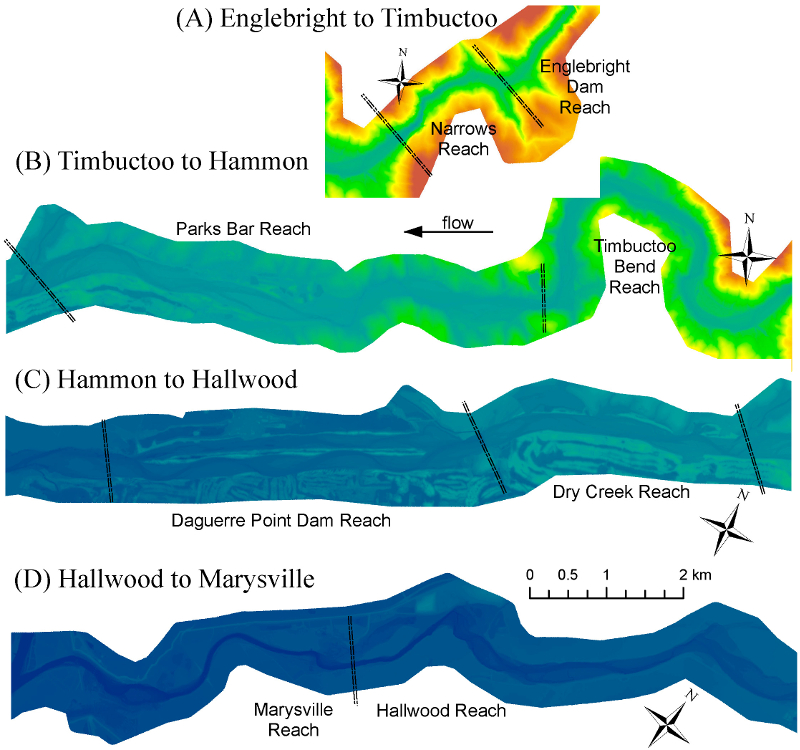
The image below shows the current topographic map of the LYR. The colors systematically change from upstream to downstream, because the river is on a slope as it progresses down the valley. red is the highest elevation and dark blue is the lowest.

Detrended LYR Topographic Map
The image below shows the current topographic map of the LYR again, but this time with the overall valley slope removed. This enables you to see more of the local detail of the river's landscape features. Red shows the highest elevation and dark blue the lowest.
![]()
LYR Topographic Map Applications
LYR maps have been used by many stakeholders, and we continue to receive requests for all of the maps for a variety of purposes. Some of the uses of the maps include the following:
- Yuba Accord studies
- Yuba River Development Project relicensing studies
- USFWS Anadromous Fisheries Restoration Program project studies
- USACE gravel injection program
- TRLIA levee project and studies
- YCWA science and management studies
- LYR restoration projects (for planning and design) by many users
- USACE Ecosystem Restoration Program feasibility study
- NMFS biological opinions
- SYRCL river studies
- Feather River Oroville Dam relicensing Habitat Enhancement Plan spring-run recovery planning
- Irrigation diversion structure analysis
- Scientific research by multiple universities
- Higher education
- Local outreach.
Bibliography
- Pasternack, G.B., 2009. Specific Sampling Protocols and Procedures for Topography Mapping: Topographic Mapping. Prepared for the Lower Yuba River Accord, River Management Team. August 2009. 17p.
- Wyrick, J. R. and Pasternack, G. B. 2012. Landforms of the Lower Yuba River. Prepared for the Yuba Accord River Management Team. University of California at Davis, Davis, CA, 91pp.
- Carley, J. K., Pasternack, G. B., Wyrick, J. R., Barker, J. R., Bratovich, P. M., Massa, D. A., Reedy, G. D., Johnson, T. R. 2012. Significant decadal channel change 58-67 years post-dam accounting for uncertainty in topographic change detection between contour maps and point cloud models. Geomorphology 179: 71-88, doi:10.1016/j.geomorph.2012.08.001.
- Weber, M. D., Pasternack, G. B. 2016. 2014 Topographic Mapping of the Lower Yuba River. Prepared for the Yuba Accord River Management Team. University of California, Davis, CA.
